Weather
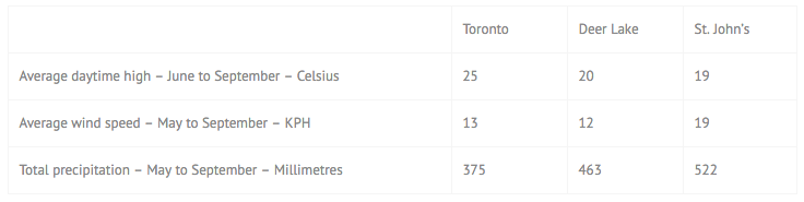
The weather in Newfoundland and Labrador is varied as a result of its size and its covering such a range of ecosystems. To help you understand what to expect, we have looked at the average of weather for the past thirty years at the airports in Toronto, Deer Lake and St. John’s. And the results are…
Airports
Deer Lake Regional Airport offers the best access to western Newfoundland, with direct flights from Toronto and Halifax. It is serviced by Air Canada, Westjet and Provincial Airlines.
Alternatively, St. John’s International Airport is the largest airport in the province with direct flights throughout North America and Europe.
Many people visiting Newfoundland arrive in either St. John’s or Deer Lake and leave through the other.
Ferry
The ferry from Nova Scotia arrives at Port aux Basques, 45 minutes from our Cape Anguille Lighthouse Inn. The ferry from Labrador serves people who wish to drive the Trans-Labrador highway. It arrives about 1 ½ hours south of Quirpon Lighthouse Inn.
For those visiting the east coast and St. John’s, the ferry from Nova Scotia to Argentia is worth considering.
Private Planes and Helicopters
Quirpon
Quirpon Island can be accessed via helicopter; we have a helipad at the inn. St. Anthony Airport is a 45-minute drive away. Shuttles to our dock can be arranged. For private planes, the details are:
Airport codes: YAY CYAY
Type: regional airport
Scheduled airline service: yes
Serves: St. Anthony, Newfoundland and Labrador, Canada
Latitude: 51.391899 | 51 23.513947 N | N51 23 30
Longitude: -56.083099 | 56 4.985962 W | W056 04 59
Field elevation: 108 ft/33 m MSL
Magnetic variation: 22.291°W
Radio communication frequencies for St. Anthony Airport:
ATF: 122.3 MHz
AWOS: 118.65 MHz (AWOS1)
CNTR: 133 MHz (GANDER CNTR)
FSS: 122.3 MHz (RDO)
RCO: 123.275 MHz (HALIFAX RDO)
RDO: 122.3 MHz (MF)
Runways at St. Anthony Airport:
10/28
4,000 x 100 ft (1,219 x 30 m) — paved — lighted
Cape Anguille
Cape Anguille Lighthouse Inn can be accessed by plane via the nearby airstrip:
Airport codes: CDA5
Type: local airport(light traffic)
Scheduled airline service: no
Serves: St. Andrews, Newfoundland and Labrador, Canada
Latitude: 47.773602 | 47 46.416092 N | N47 46 24
Longitude: -59.313099 | 59 18.785934 W | W059 18 47
Field elevation: 65 ft/20 m MSL
Magnetic variation: 20.436°W
Radio communication frequencies for St. Andrews Codroy Valley Airport:
ATF: 123.2 MHz
Runways at St. Andrews Codroy Valley Airport:
18/36
3,000 x 75 ft (914 x 23 m) — paved — lighted